
Corsica captivates with its unmatched variety of landscapes, from dreamy coastlines and soaring mountains to gorgeous lakes, where scenic trails allow you to hike right into the island’s best spots. With more than a thousand kilometres of stunning routes, outdoor lovers seeking a thrilling adventure can uncover nature’s best-kept secrets accessible only on foot.
In this guide, I present Corsica’s 11 most beautiful hikes, for every skill level, sure to wow even the most avid walkers. You can also check out my other post, where I list the island’s 7 best easy trails suited to casual explorers who enjoy leisurely, relaxed recreation.
This page contains affiliate links meaning I get a commission if you decide to make a purchase through my links, at no extra cost to you. Click here to learn more.
PLANNING A TRIP TO CORSICA? CHECK OUT THESE RESOURCES!
SAFETY ON THE CORSICAN TRAILS
Safety precautions are paramount on Corsica’s rugged trails. Thorough preparation mitigates risks, ensuring a safer, more rewarding adventure.
- Research extensively- plan your itinerary using up-to-date trail maps and verify current conditions.
- Assess your fitness level and experience before committing to demanding treks.
- Check the forecasts and cancel your hike in case of a storm, rain or strong winds. Expect sudden weather changes at high altitudes.
- Avoid river valleys during and immediately after rain, as flash floods can dramatically raise water levels.
- Gear up fully. Carry essentials adapted to your hike’s length and difficulty level, such as proper hiking shoes, trekking poles, layered clothing, sun/rain protection, high-energy food, water, a first-aid kit, a headlamp, and a satellite communicator (signal is very patchy in mountainous areas and canyons).
- Inform a trusted contact of your route and timeline. Consider hiking with a partner in Corsica’s remote sections.

1. GR20 HIKE – CORSICA’S LEGENDARY LONG-DISTANCE TRAIL
LOCATION across Corsica DISTANCE 180 km ELEVATION 12000 m DIFFICULTY LEVEL very difficult
The king of long-distance hikes, Corsica’s legendary GR20, runs roughly 180 kilometres along the island’s rugged mountain spine, from Calenzana in the north to Conca in the southeast. Often described as Europe’s toughest waymarked trek, it demands excellent fitness, a head for heights, and confidence on steep, very rocky terrain.
Over about 10-16 days, hikers tackle relentless ascents, scrambles over granite slabs and exposed ridges, especially in the challenging northern section, while staying in simple refuges or designated campground areas. In exchange, they witness Corsica at its wildest- high summits, glacial lakes, such as the mentioned here Lac de Nino, and dramatic massifs, including Aiguilles de Bavella.
ACCESS – GR20 is bidirectional, however, it is most often hiked north-to-south, confronting the steeper sections early. It begins in Calenzana, in the Balagne region, and ends in Conca, north of Porto Vecchio. Both villages are served by public transport (buses) or taxis.
USEFUL TIP – Conquering the GR20 crowns many explorers’ dreams, yet requires superb physical condition and dedicated training. Hikers are often surprised by the trail’s mercilessly stony character preventing stable footing and vertigo-inducing all-four scrambles.
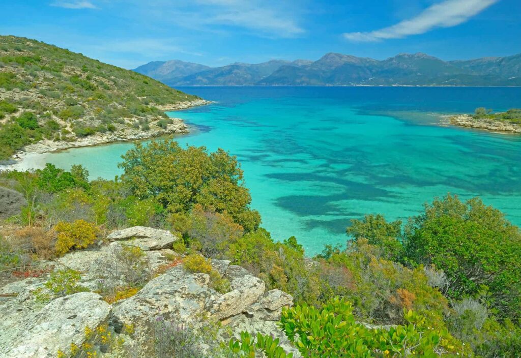
2. SENTIER DES DOUANIERS HIKE – WILD AGRIATES SHORES WITH PARADISE BEACHES
LOCATION north Corsica DISTANCE 37 km ELEVATION 400 m DIFFICULTY LEVEL moderate
Sentier des Douaniers, along Désert des Agriates, is one of Corsica’s most breathtaking coastal hikes, tracing 37 kilometres of untouched shoreline between Saint-Florent and Plage de l’Ostriconi. Winding through fragrant maquis, the trail unveils a natural paradise of turquoise coves, wild headlands, and pristine white-sand beaches like the famous Lotu, Saleccia, and Ghignu. Once used by customs officers patrolling the coast, today it attracts hikers into a world of raw beauty and silence where sea and the granitic littoral meet. Though long, the path can be explored in sections, each offering solitude, primal landscapes, and sublime views of the glittering Mediterranean.
ACCESS – The coastal customs officers’ path starts at Plage de la Roya in Saint Florent and runs along the coast until Plage de l’Ostriconi. The entire 37-kilometre itinerary is usually covered over 2-3 days. For a relaxing family-friendly day outing with swims, follow the trail to Plage de Fume Santu (1h30min) or Tour de la Mortella (1h50min), a historic Genoese tower.
USEFUL TIP – Agriates’ summer brings scorching heat and strong winds- carry 3-5 litres of water per person daily. Skip hiking during storms and heavy rain, which can trigger sudden floods in stream deltas.
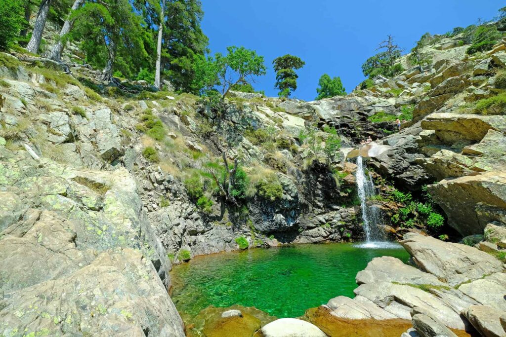
3. CASCADES DE RADULE HIKE – ENCHANTED WATERFALLS IN CORSICA’S MOUNTAINS
LOCATION central Corsica DISTANCE 4.3 km round trip ELEVATION 155 m DIFFICULTY LEVEL moderate
Cascades de Radule walk will leave you with vivid memories- crystalline waterfalls spill over smooth granite into emerald pools, creating an idyllic refuge perfect for cooling off or simply admiring. Surrounded by old forests and mountain peaks, Radule feels like a hidden world- beautiful, calm, and untouched. Starting near Col de Vergio, the ascending blue-marked trail soon merges with sections of the long-distance GR20. Past Bergeries de Radule, continue towards Golo River and its footbridge, to turn right just past it into a steeply descending Mare a Mare Nord.
ACCESS – This short hike starts from the D84 road near Albertacce, below Col de Vergio. Park your car on a horseshoe hairpin bend known as Le Fer à Cheval, 4 km before the pass.
USEFUL TIP – Skip hiking in bad weather like storms, rain or high winds- flash floods can surge water levels rapidly in the Corsican mountains.

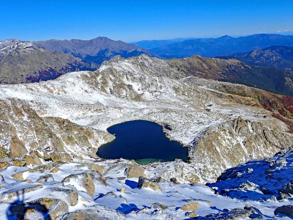
4. LAC DE NINO HIKE – TIBETANESQUE SCENERY AND WILD HORSES
LOCATION central Corsica DISTANCE 10.2 km round trip ELEVATION 730 m DIFFICULTY LEVEL difficult
The hike to Lac de Nino, in the wild, centrally-located Niolo Valley, is often considered Corsica’s most scenic outdoor escapade. The trail leads to awe-inspiring alpine landscapes, where a tranquil glacial lake dazzles amidst rolling meadows and snow-dusted towering peaks.
Starting from the maison forestière of Poppaghia (1076 m), it climbs through pine woods and rugged terrain to eventually reach the Camputile plateau sheltering Lac de Nino (1743 m). Along the way, you will enjoy views of Paglia Orba and Capu Tafunatu, Corsica’s revered summits. At the top, wild horses graze beside the lake’s shimmering pozzi, creating a serene, almost mystical scene. Though demanding and exposed, this iconic route delivers an unforgettable immersion in Corsica’s virgin nature.
ACCESS – The trail to Lac de Nino starts by the D84 road, 14 km southwest of Calaccuccia and 7 km from the Verghio pass, near the maison forestière of Poppaghia. From the car park, a yellow-marked path departs into the Valdo-Niolo forest.
USEFUL TIP – Rated difficult, the trek demands special focus on its technical descent for precise foot placement. Pack plenty of water as there are no sources along the way.
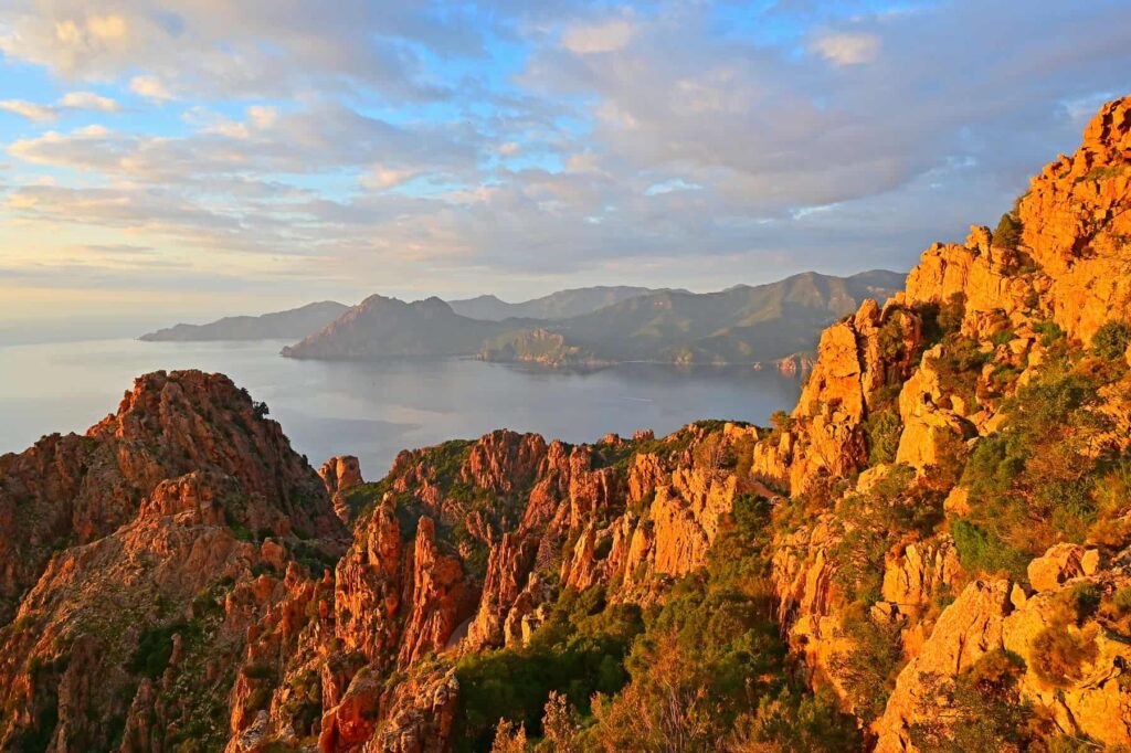
5. SENTIER DES MULETIERS HIKE – EPIC VIEWS OF CALANCHES DE PIANA
LOCATION west Corsica DISTANCE 3.2 km round trip ELEVATION 165 m DIFFICULTY LEVEL easy
The ancient mule trail (Sentier des Muletiers) twisting above Calanches de Piana offers a short yet thrilling walk amid Corsica’s most dramatic coastal scenery. Every turn unveils a new spectacle of sculpted rock and sea, making this route unforgettable for nature lovers.
Starting near Piana’s stadium, the yellow-marked path winds through pine woods before revealing spectacular views of the UNESCO-inscribed crimson cliffs plunging into the deep blue Gulf of Porto. Once used by villagers and traders, this well-preserved stone track now enchants hikers with its bewildering panoramas. Though generally easy, it includes exposed sections and rocky steps that demand focus, particularly if hiking with children.
ACCESS – The trek starts at the Stade Municipal de Piana football pitch, 1.6 km east of the village, off the D81 scenic road. From the car park, continue across the pitch where two small bridges lead to a yellow-marked path marked Ancien Chemin de Piana à Ota.
USEFUL TIP – For the best experience, hike Sentier des Muletiers in late afternoon- the setting sun bathes twisted rocks in vibrant red, orange, and pink hues, while lengthening shadows highlight their dramatic shapes.

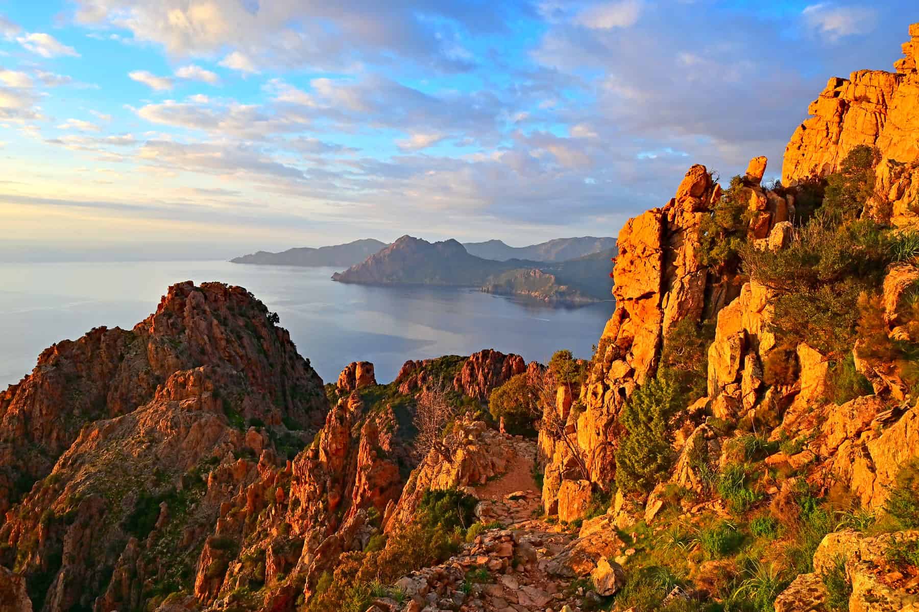
6. CAPO ROSSO HIKE – COASTAL ASCENT OF THE ICONIC CRIMSON ROCK
LOCATION west Corsica DISTANCE 8 km round trip ELEVATION 450 m DIFFICULTY LEVEL moderate
The hike to Capo Rosso, a landmark of Corsica’s wild west coast, offers one of the island’s most striking viewpoints. Beginning near Piana, this 8 km round trip descends gently before its steep final climb to a pyramid-like rock crowned by the 17th-century Tour de Turghiu. A well-marked path, initially engulfed in the aromatic maquis, offers sweeping views of red granite cliffs plunging into turquoise seas. Moderately challenging, the effort eventually culminates with a spectacular panorama over the Porto and Sagone Gulfs, especially mesmerising under the golden glow of sunset.
ACCESS – The Capo Rosso trail begins 6km west of Piana on the D824 road to the stunning Arone beach. From the car park, follow a stony westward path marked by the Conservatoire du Littoral panel.
USEFUL TIP – The trail is exposed with very little shade available and no water points- bring adequate sun protection and drink ample fluids (at least two litres per person).

7. LAC DE MELO HIKE – ALPINE JEWEL CROWNING RESTONICA VALLEY
LOCATION central Corsica DISTANCE 16 km round trip ELEVATION 900 m DIFFICULTY LEVEL very difficult
The trail to Lac de Melo winds through Restonica Valley’s spellbinding wilderness, leading adventurers into striking mountain scenery and rugged alpine landscapes. Rising steadily from forested slopes to rocky pastures, it offers a physically demanding yet immensely rewarding ascent into the heart of Monte Rotondo Massif.
The hike begins at the A Frasseta car park (900 m) on D623 and climbs via Bergeries de Grotelle (1375 m) on a red-marked path, to finally ascend a steeper yellow route to the lake. At 1710 meters, Lac de Melo reveals itself- a tranquil, emerald basin framed by sheer peaks and sweeping meadows, a pristine reward for those who venture into this untamed corner of central Corsica. Due to its length and elevation, the trail is only suitable for expert hikers in top health.
ACCESS – Following severe floods of 2023 that damaged the D623 road through Restonica Valley, private vehicle access is now restricted. From early May to the end of September, a dedicated shuttle, Navetta Restonica C13, operates between the Corte station (Corti Gara) and A Frasseta, the trailhead for the Melo Lake hike. Book in advance (€4 round trip) via the M-Ticket Via Corsica Restonica app, as there is no network coverage in the valley.
USEFUL TIP – Carry plenty of water and high-calorie snacks for extra energy on steeper climbs. A source of potable water is only available near Melo Lake. With reserves left, you can ascend further to Lac de Capitello, nestled above Melo at 1930 meters.
8. LAC DE BASTANI HIKE – GLACIAL GEM AT THE FOOT OF MONTE RENOSO
LOCATION central Corsica DISTANCE 6 km round trip ELEVATION 550 m DIFFICULTY LEVEL moderate
Lac de Bastani is an emerald, high-altitude jewel hidden from crowds at 2090 meters altitude amid Monte Renoso’s arresting massif. This heart-shaped, deep lake stays frozen for seven months, providing pristine habitat for endemic trout and salmon. The ascent from U Renosu gite (1670 m) takes 1h30min, passing through the serene Plateau de Pizzolo (1893 m), where free-range cows graze amid verdant pozzi. The trail culminates with rocky climbs, but the effort is worth Bastani’s jaw-dropping scenery. Seasoned hikers may push on for another hour to the towering peak of Monte Renoso (2352 m).
ACCESS – Arriving from Ghisoni, take the D69 road towards Col de Verde and after 6 km, turn right into D169 ascending to the Capanelle ski station. At the end of the winding route, follow the road signposted for the U Renosu gite until you reach the car park. The trail starts past a small bridge.
USEFUL TIP – The best time to enjoy this hike is between June and October, when the trail is snow-free. As the area is exposed to strong, cold winds, bring a protective layer and headwear. Hiking shoes are indispensable.
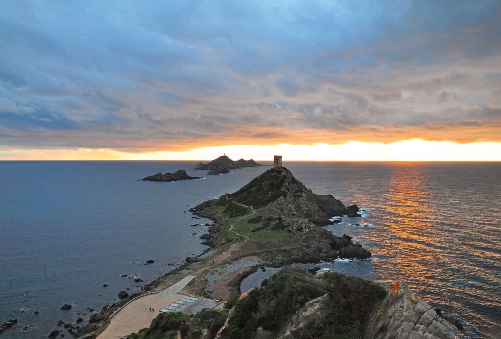
9. PARATA PENINSULA HIKE – SUNSET MAGIC WITH VIEWS OF ILES SANGUINAIRES
LOCATION west Corsica DISTANCE 2.7 km loop ELEVATION 50 m DIFFICULTY LEVEL easy
The easy Parata Peninsula loop west of Ajaccio is a must-do activity for families and casual hikers visiting Corsica’s colourful capital. It delivers stunning Iles Sanguinaires views, especially at sunset, when the volcanic rocks glow crimson. From the parking lot at the end of Route des Sanguinaires, follow the shore-hugging path with a quick uphill detour to the majestic Genoese watchtower, the prime spot for Ajaccio Bay panoramas at dusk. Although the circuit takes only 50 minutes, it will tempt you to stay longer, enjoying perfumed maquis, endemic birds, and the site’s irresistible magic.
ACCESS – If you arrive by car, follow the coastal Route des Sanguinaires (D111) running 11 km west from Ajaccio, until you reach a large Parata car park at the road’s end. You can also get to La Parata by bus (line 5) from Place de Gaulle.
USEFUL TIP – Although short, the trail requires comfortable hiking shoes. Along Route des Sanguinairea are some of Ajaccio’s most beautiful beaches where you can stop for a quick dip or picnic.
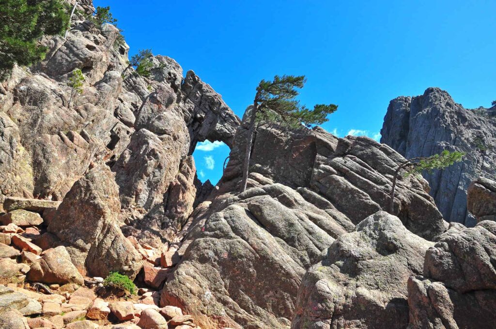
10. TROU DE LA BOMBE – HYPNOTIC PANORAMAS OF BAVELLA’S GIANT PEAKS
LOCATION south Corsica DISTANCE 5.7 km round trip ELEVATION 213 m DIFFICULTY LEVEL easy/moderate
The scenic trail to Trou de la Bombe, departing from Col de Bavella, is one of Corsica’s most popular easy hikes, and for a good reason. Winding through pine-shaded hills, void of notable technical difficulties, it superbly showcases the dramatic Aguilles de Bavella pinnacles. The path ends at a massive rock featuring an 8m-wide erosion-carved hole, a great spot for stunning photos.
From the information point, follow red markers up the wooded path, passing Chapelle de la Sainte Vierge, to eventually turn left towards U Cumpuleddu at the crossroads. Panoramas along the way are magnificent. The finale involves a steep rocky climb to the viewpoint. Don’t climb the rocky hole- fatal accidents have occurred from its sheer drop.
ACCESS – The trail starts at Col de Bavella (1218 m) on the scenic D268 – D368 route linking Porto Vecchio and Solenzara. Leave your vehicle at a large lot located on the pass (€5 in summer, otherwise free). In the highest season, you can also use the Viséo 360-space car park, 5.6 km south-west of Bavella, with a free shuttle service.
USEFUL TIP – If you visit in summer, arrive early to avoid crowds. Before setting out, check the weather forecast and cancel your trip in case of adverse conditions.

11. ESCALIER DU ROY D’ARAGON HIKE – STEEP LIMESTONE STAIRCASE CARVED INTO BONIFACIO’S CLIFFS
LOCATION south Corsica DISTANCE 189 steps/ 0.6 km round trip ELEVATION 55 m DIFFICULTY LEVEL moderate
Although it’s not truly a hike, I had to include in this list the Escalier du Roy d’Aragon descent, an unforgettable Bonifacio adventure into the island’s coastal grandeur. Carved directly into the limestone cliff, its 189 uneven, narrow steps plunge at a dizzying 45-degree angle toward the turquoise sea below.
Surrounding colours are stunning and the seascapes majestic. As you descend, the bright white rock face gleams against the deep blue of the Mediterranean, with waves pounding beneath the overhangs. At the base, a narrow path hugs the wall above the water, leading to the ancient (now fenced-off) Saint-Barthélemy well, once vital for fresh water. The steep, vertigo-inducing climb back up is demanding, but the cliffs’ intimate proximity, paired with views of Sardinia make every step worthwhile.
If you enjoy Bonifacio’s striking scenery, you can also set out on a walk atop the cliffs. To find more information about this panoramic hike, consult my article about Corsica’s best easy trails.
ACCESS – The staircase entrance is located within Bonifacio’s citadel near Eglise Saint-Dominique. Tickets cost €5.
USEFUL TIP – Flat, close-toe shoes are obligatory. You will be provided a helmet for head protection. In summer, arrive early to avoid crowds and midday heat.
TRAVELLER’S COMPANION FOR A TRIP TO CORSICA – GRAB YOUR EBOOK!
33 Natural Pools and Waterfalls in Corsica
Descriptions – Directions – Coordinates
GRAB YOUR E-GUIDE TO CORSICA’S STUNNING NATURAL POOLS
Discover Corsica’s natural pools and waterfalls with a concise guide featuring 33 stunning river spots across the island. Perfect for wild swimming, family outings, and nature exploration, it provides clear access details, GPS parking coordinates, and nearby attractions. From peaceful basins to dramatic cascades, it helps you safely navigate the island’s rugged landscapes and uncover hidden gems beyond well-trodden tourist paths. Great for planning outdoor adventures, this practical 51-page eBook can be your companion on a journey to Corsica’s pristine rivers.
YOU MAY ALSO LIKE
- Top 7 easy hikes in Corsica – outdoor adventures
- 7 Amazing scenic drives in Corsica for road trip lovers
- 10 Must-visit towns in Corsica for your island getaway
- Natural swimming pools of Restonica
- Best things to do in Corsica with children
- Top 11 most beautiful places in Corsica
- 15 hidden gems in Corsica – discover the island’s best-kept secrets
- Cavu natural swimming pools – a hidden paradise in Corsica
- 7 Magical waterfalls in Corsica every nature lover should see
- Hiking beneath Corsica’s highest peaks – Bergerie de Ballone & Refuge de Tighjettu trail
- What to avoid in Corsica – 11 common mistakes
- Corsica- where to go and what to do
- Route de Bavella – the most beautiful mountain drive in Corsica
- Trou de la Bombe – hiking to the hidden gem of Bavella
- Plateau du Coscione – your ultimate outdoor escape in Corsica
- Where to stay in Corsica – best places and areas for your visit
- Corsica’s best beach hotels and top coastal locations
- Best places to stay in Corsica for couples
- 16 Stunning Bonifacio beaches you can’t miss
- 11 Best beaches in Ajaccio – top spots to swim and relax in Corsica’s capital
- 11 Charming Corsican villages that will steal your heart
Liability Disclaimer
All outdoor activities are carried out at your own risk. Always plan ahead and be cautious when preparing for your hikes. The author of this blog cannot be held responsible in the event of an accident, death, loss, personal injury, or any other inconvenience or damage that may be sustained by anyone as a result of the use of any information contained on this website.
PLANNING A TRIP TO CORSICA? CHECK OUT THESE RESOURCES!